The Essex Region Conservation Authority is monitoring a weather system that could bring copious amounts of mixed precipitation this week.
ERCA has issued a flood watch until Thursday afternoon for the region, with the forecast calling for rain to move in on Wednesday.
"In the past seven days, the Essex Region experienced some mild temperatures with a small amount of mixed precipitation," said ERCA Watershed Management Director James Bryant. "This small amount of precipitation was mostly direct runoff as the ground conditions were still relatively frozen. Temperatures have since quickly dropped below zero with much of this runoff frozen in agricultural fields. Forecasts are now predicting a quick rise in temperature on Wednesday into Thursday."
The Environment Canada forecast as of 7 p.m. Tuesday called for winds to pick up Wednesday afternoon, and rain moving in late Wednesday night. Rain will continue Thursday, and temperatures will fall throughout the day, changing the precipitation to freezing rain or ice pellets, then snow Thursday night. A special weather statement issued Tuesday said the area could see 10 to 25 millimetres of rain.
"This combination is expected to generate an increased amount of runoff, with standing water expected in low-lying areas across the region," said Bryant. "Surface drainage features such as roadside ditch and municipal drains may not have their full capacity available as the mixture of salt and snow can sometimes form blocks of thick ice within the drains through various freeze-thaw cycles."
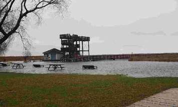
Residents are being asked to stay clear or areas where water may easily pool, and stay way from the edges of rivers, streams, or lakes during rainfall.