The calendar flipped to December with a moisture-laden low pressure system churning over southwestern Ontario, dumping heavy snow.
As expected in Sarnia-Lambton, the heavier snow is falling inland with Environment Canada forecasting the potential for another 15 centimetres to 30 centimetres, six to 12 inches, of snow through the day and into the evening Tuesday.
The snowfall warning was updated Monday morning.
Meteorologist Geoff Coulson said the worst conditions will be east of Sarnia with heavy snow in an enhanced band between Sarnia and London.
"In many areas east of Sarnia, towards the London area, easily 15 more centimetres during the day today and locally up to 30 centimetres in some of these heavier bands of snow," said Coulson. "Definitely a heads up for anyone planning travel along the 402 that if they leave Sarnia, it's not looking that bad, they could be driving into some stronger stuff as they move eastwards toward London."
Poor visibility is expected in quickly accumulating snow and blowing snow on strong northwest winds to 70 kilometres an hour.
The strong winds are expected to continue into Tuesday night before the slow-moving system moves east.
By Tuesday morning, the City of Sarnia had received around five centimetres with higher amounts of 10 centimetres in north and east Lambton. At Strathroy, 16 centimetres of snow had fallen by 8 a.m. according to Environment Canada.
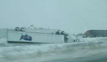
OPP reported weather-related crashes across the region including a tractor trailer that rolled in the Strathroy area. The eastbound lanes of Highway 402 were closed between Kerwood Road and Centre Road.
Motorists are urged to adjust to changing conditions and to put travel plans off if possible until the storm system clears the region Wednesday.
 Tractor trailer rollover on Highway 402. 1 December 2020. (Photo by Township of Warwick Fire & Rescue Department)