This latest summer 2020 heat wave will be short-lived.
Environment Canada's heat warning remains in effect but a cold front will pass through southern Ontario from west to east Monday evening, bringing in slightly cooler and drier air for Tuesday.
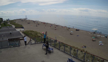
It was a sizzling hot Sunday.
The temperature climbed to 33.3 C, 92 F, at Sarnia's Chris Hadfield Airport, breaking the previous record high for July 26 of 31.2 C set in 1989.
A high of 32 C, 90 F, and a humidex of 41 C, 106 F, is forecast Monday.
As usual there's the chance of severe thunderstorms in advance of the cold front. Environment Canada has a severe thunderstorm watch in effect for Sarnia-Lambton from mid-afternoon to late evening with strong wind gusts and heavy rain the main threats.
The weather agency reminds the public that hot and humid air can also bring deteriorating air quality and result in the air quality health index approaching the high risk category.
Extreme heat affects everyone.
The risks are greater for young children, pregnant women, older adults, people with chronic illnesses and people working or exercising outdoors.
Check on older family, friends and neighbours. Make sure they are cool and drinking water
Reduce your heat risk. Schedule outdoor activities during the coolest parts of the day.
Never leave people or pets inside a parked vehicle.
Outdoor workers should take regularly scheduled breaks in a cool place.