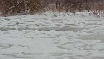
Maitland Conservation has issued a Flood Watch for all municipalities in the Maitland and Nine Mile River watersheds as ice jams have formed, which could lead to flooding.
Signs of ice jams have been observed in larger river reaches. including the Lower Maitland River near Wingham, the South Maitland River near Summerhill, and the Nine Mile River in Port Albert. Most smaller streams throughout the watershed are ice-free.
The conservation authority reported river levels have either peaked or are nearing peak flows, but falling temperatures create the risk of blockages from ice jams freezing in place.
"Ice jams are unpredictable - they can form, shift, worsen or break up suddenly," read a statement from Maitland Conservation. "These blockages cause rapid changes in water levels and localized flooding, even in non-traditional areas. While Maitland Conservation will monitor known ice jams, there’s risk that unknown or new jams may form elsewhere in the watershed."
Municipal officials are encouraged to check low-lying roads and infrastructure. People are reminded that areas around all watercourses remain hazardous. Maitland Conservation is monitoring watershed conditions and will provide an update if warranted.
The Flood Watch is in effect until the afternoon of Friday March 7, 2025.