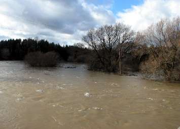
Conservation authorities in Midwestern Ontario are monitoring the warm and rainy conditions which will lead to high water flows and minor flooding.
Rainfall amounts of 10 to 25 mm are expected locally Tuesday, with temperatures reaching near 10 degrees Celsius by late afternoon. Some melting of the remaining snowpack can be expected to increase the potential for runoff and elevating water levels. Current snowpack data shows approximately 15-30 mm of water equivalent in the snowpack
The Maitland Valley Conservation Authority has reissued a flood watch for the Lower Maitland River including Saltford, and the mouth of the Nine Mile River in Port Albert. That follows the formation of ice jams last week and the potential for another rise in river levels. Its expected ice breakup throughout the watershed will likely continue with elevated flows and may worsen existing jams. There’s also potential for new jams to form, typically at any major crossings, culverts, and river bends upstream of major river outlets. A sudden drop in temperature tonight may strengthen jams and prolong the situation until the next warmup.
The Saugeen Valley and Ausable Bayfield Conservation Authorities have issued flood outlook statements.
The MVCA says the risk of ice-jam-related flooding is very low, as weakened river ice is only present in the Port Franks and Grand Bend areas. A quick snowmelt and runoff is expected but major flooding is not anticipated.
The SCVA says local watercourses could become overwhelmed leading to localized flooding in low lying areas. River ice that was weakened during last week’s rainfall event may breakup or jam in response to warmer temperatures, forecast rainfall and rising water levels. As below freezing temperatures resume overnight and into tomorrow, there is a potential for flash freezing and jamming of ice. Ice jams can occur anywhere within a river system, but typically occur in areas near culverts, bridges, and river bends.