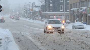
The calendar may read spring, but the weather outside will make it seem more like mid-winter.
Environment Canada expects conditions Wednesday to be favourable for snow squalls brought on by a sharp cold front moving south through the London region. The lake effect snow is expected to develop in the afternoon and continue into Thursday. Peak snowfall rates of 2 to 4 centimetres per hour are possible.
The squalls could bring between 15 to 35 centimetres of snow to the area before tapering off Thursday afternoon.
The national weather agency initially had London and eastern Middlesex County under a snow squall watch. It was upgraded to a warning around noon. A weather advisory is in place for western Middlesex, Elgin, and Oxford counties.
"Strong northwesterly winds along with the lake effect snow squalls will lead to significantly reduced visibility," Environment Canada warned. "Travel may be hazardous due to sudden changes in the weather. Visibility may be significantly and suddenly reduced to near zero. Rapidly accumulating snow could make travel difficult over some locations."
Drivers are advised to consider postponing non-essential travel until conditions improve. Those who have to venture out should slow down, increase following distance, and keep headlights switched on.