The St. Clair Region Conservation Authority issued a flood watch Tuesday with a lot of rain expected over the next few days.
The authority said 40 millimetres to 55 millimetres of rain is forecast through Thursday.
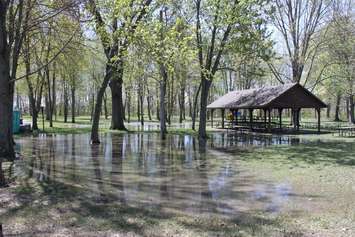
Water levels already elevated from last weekend's rain are expected to rise further, with the potential for localized flooding in floodplain areas, parks and farm fields.
Southwest winds will contribute to the higher water levels by causing a backwater effect, slowing the flow of water.
The authority also warned that high amounts of rain in a short period of time can lead to increased runoff and flash flooding, particularly in urban areas.
Residents are reminded to avoid watercourses and flooded areas across the watershed.
Roads that will be closed due to high water levels include:
- Stanley Line east of Kimball Road
- Pretty Road north of McCallum Line
- Waterworks Road between Moore Line and Courtright Line