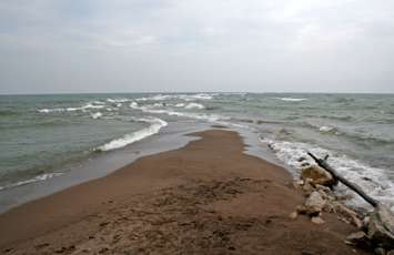
The next time you're at Point Pelee National Park, take a picture of the coastline.
Researchers at the University of Windsor are studying the coastlines at five national parks, including Point Pelee.
Cell phone cradles will be installed in specific areas along the coasts, and visitors can scan a QR code at the Coastie site, submit their photos to coastiecanada.ca, or share them on social media using the hashtag #Coastie.
Students at St. Clair College created the first cradles.
The researchers will analyze the data to track changes like shoreline retreat, dune erosion and recovery, storm surge, ice cover, vegetation, beach use, and rip currents.
"Citizen science is an ideal way for us to collect the very important information we need to monitor shoreline changes across Canada," said Dean of the University of Windsor's Faculty of Science and project lead Chris Houser. "It's also a great opportunity for people to learn first-hand about beaches, shorelines, rip currents, and the importance of protecting the environment."
Research is also underway at Prince Edward Island National Park, Fundy National Park, Kouchibouguac National Park, and Sable Island National Park Reserve. More parks should join the project next year.