Worsening weather conditions along a portion of Lake Erie have resulted in a flood warning being issued.
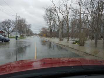
The Essex Region Conservation Authority (ERCA) has issued a flood warning for the Lake Erie shoreline in Leamington, particularly between Mersea Road 2 and Fox Run Road. As of 1:30 p.m. Friday, Watershed Management Services Director James Bryant said that section of "roadway is completely inundated and impassable."
The shoreline area between Marentette Beach Road and East Beach Road north of Road 1 Dyke is also experiencing flooding and some sections of the roadway are underwater.
In the Town of Kingsville, the Lake Erie shoreline and Cedar Creek area are also experiencing flooding. County Road 50 (Heritage Road) west of Cedar Creek Bridge also has some localized ponding along sections of the pavement with the roadway being low-lying combined with wave spray, rainfall, elevated water level in Cedar Creek. Cedar Creek water levels are elevated and there is a high risk of flooding in private lands and low-lying sections of roadway between Conservation Blvd. and Ford Road.
ERCA had issued a flood watch on Thursday night for the entire Lake Erie and Lake St. Clair shorelines. That watch remains in effect through at least Sunday.
Drivers are being asked to keep their vehicles out of the affected area and not drive through unless absolutely necessary. Water flowing over the road may result in hazards being concealed, like curbing, washouts, loose debris, and so forth,
The flood warning will be updated as required and is in effect through Sunday, along with the flood watch.