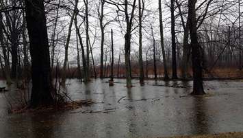
The St. Clair Region Conservation Authority has issued a flood watch for the watershed.
Between 25 and 35 millimetres of rain fell overnight Thursday and Friday morning, resulting in elevated water levels.
The authority said with above-seasonal temperatures expected to continue through the weekend, the combined snow melt and rain could result in localized flooding in floodplain areas, parks, and farm fields.
Water levels continue to rise, and the following roads have been closed due to flooding.
Stanley Line between Kimball Road and Waubuno Road
Plowing Match Road between Rokeby Line and Petrolia Line
Black Ash Road between Durham Creek Line and Rokeby Line
Gypsie Flats Road between Durham Creek Line and Rokeby Line
We're reminded to avoid watercourses and flooded areas due to dangerous conditions, slippery banks, and cold, swift-moving water.
The frozen ground has a reduced ability to absorb the rainfall and has become saturated, which could also contribute to ponding and increased runoff into watercourses.
The Conservation Authority will continue to monitor watershed conditions over the weekend, and will issue any necessary advisories.
The flood watch is expected to remain in effect until Monday.
Lambton Public Health is also advising homeowners with private wells to test their water supply. The health unit said the high levels of rain and snow melt could result in harmful bacteria entering the drinking water supply.