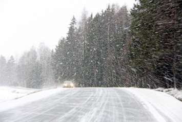
Midwestern Ontario residents are bracing for a significant winter storm set to hit the region this weekend, bringing dangerous blizzard-like conditions and potential travel disruptions.
A winter storm warning was issued late Friday afternoon.
Environment Canada Meteorologist Steven Flisfeder shared insights into the upcoming weather event, emphasizing the severity of the storm.
"Winter has arrived in full force across Ontario, with a major low-pressure system expected to rapidly intensify as it heads into the Great Lakes region on Friday," says Flisfeder. "We're anticipating dangerous blizzard-like conditions from Friday night into Saturday, with the potential for extensive blowing and drifting snow, localized wind damage, and power outages."
Compared to the recent Texas low that brought slushy conditions, this storm is expected to have more cold air, less moisture, and significant snowfall totals in some areas. Flisfeder warned of the risk of widespread snow, slower travel times, and the possibility of a rain/snow mix along the Lake Huron shoreline.
The timeline for the storm's impact was outlined, indicating that a weak clipper system on Thursday would drop up to 5 cm of snow. The main event, however, is expected to unfold late Friday and into Saturday.
"By late Friday afternoon, the system will move into southwestern Ontario, intensifying rapidly by the evening," Flisfeder explained. "This could lead to a high-impact scenario during the evening commute with heavy snow and gusts between 60-80 km/h. Travel is not recommended."
The storm is predicted to engulf most of the province by midnight, with snowfall rates reaching 3-5 cm per hour. A widespread swath of 10-20 cm of snow is possible, with some areas potentially exceeding the 20 cm mark.
Flisfeder highlighted the significance of stronger winds accompanying this storm, increasing the risk of whiteouts and blizzard-like road conditions across Huron, Perth, Bruce, Grey and Wellington counties. Sustained winds of 60-80+ km/h are possible.
As the storm passes, colder than seasonal temperatures will dominate, setting the stage for a multi-day lake-effect snow squall event that will likely continue into next week. Flisfeder warned of hazardous travel conditions due to meandering bands of snow squalls across specific regions.
Residents are advised to stay informed about the changing weather conditions, check highway updates before traveling, and take necessary precautions to ensure safety during this winter storm.