The weather situation in Midwestern Ontario is set to take a turn for the worse very shortly, and some meteorologists are concerned that residents may not be taking the threat of the upcoming storm seriously.
Both Environment Canada and the National Weather Service in Buffalo, New York have sent messaging that urges residents around the Great Lakes to properly prepare for the effects of the upcoming weather system, warning that elements exist for a "historic" storm that could slow most of Southwestern Ontario and portions of the surrounding area for several days, although the worst seems to be centered on Huron, Perth, Bruce, Grey, and Wellington counties.
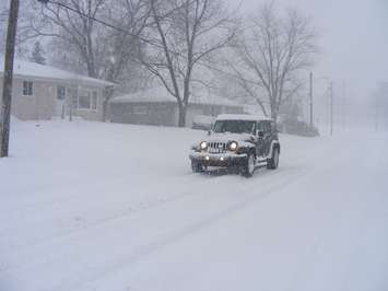
On Thursday morning, Environment Canada issued a blizzard warning for all of Midwestern Ontario.
https://twitter.com/NWSBUFFALO/status/1605542943879827458
https://twitter.com/ECCCWeatherON/status/1605326630649462786
Huron County has already declared a Significant Weather Event ahead of the storm, with the expectation of "flash freeze conditions based on weather forecasts and observations." The County says users of its roadways are advised to avoid unnecessary travel and to use extra caution if doing so. The City of Owen Sound has also declared a significant weather event.
According to the latest models, all of Midwestern Ontario will be impacted by this storm, with light rain beginning on Thursday afternoon and into Thursday evening, when that rain transitions to snow. On Friday morning, there is a risk for a "flash freeze" due to dropping temperatures, with light snow transitioning to heavier snow on Friday afternoon as wind gusts increase. By Friday evening, "damaging wind gusts" are forecast, with blizzard conditions expected in the area immediately east of Lake Huron.
Saturday (Christmas Eve) is not expected to be much better, with strong wind gusts continuing in the morning and snow squalls for most of Grey and Bruce, as well as the northern portions of Perth, Huron and Wellington counties. Lake effect snow is expected to become less intense by Saturday evening before picking back up again overnight amid temperatures near -20 C.
For Sunday (Christmas Day), travel in Grey and Bruce counties is described as "near impossible" in some forecasts with lake effect snow continuing into the afternoon before diminishing, although roads by this point are expected to be still covered by a large amount of snow. A third night of very cold temperatures overnight is expected to follow.
The Ausable Bayfield and Saugeen Valley Conservation Authorities have both issued a Flood Outlook message.
On Friday, Gueph Owen Sound Transportation will operate the morning run departing from Owen Sound at 7:30 a.m. and departing from Guelph at 10:40 a.m., but the afternoon run which leaves at 2:30 p.m. is cancelled.