People need to stay well back from waterways and the Lake Huron shoreline due to fast water and high waves.
The up to 35 mm of rain received since midnight has resulted in a quick runoff and rapidly rising water levels in the Ausable Bayfield, Maitland, and Nine Mile watersheds. That means minor flooding is possible, and waterways will be fast and frigid.
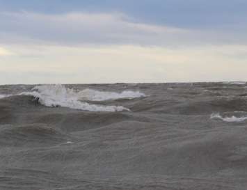
And over the next day, the low-pressure system will bring strong northwest winds gusting to 70 km/hr. along the Lake Huron shoreline. Wave heights and saturated ground conditions may result in an increased risk of erosion to lakeshore bluffs. People should avoid top-of-bluff areas during and immediately after the storm in case there has been any movement of the lake bank.
Based on current weather and streamflow forecasts, levels in watercourses will exceed bank-full conditions, resulting in minor flooding of traditional low-lying flood plain areas. Water levels will be similar to those experienced earlier this spring.
Residents are reminded to use caution near all watercourses. Significant flooding is not expected, but slippery and unstable streambanks and extremely cold and fast-flowing water will combine to create hazardous conditions.
Levels in smaller watercourses are projected to peak later today with larger rivers peaking late tomorrow. Flows are expected to remain above seasonal into next week.
Meantime, The Middle Maitland Rejuvenation Committee has postponed the Annual River Clean-up scheduled for tomorrow in Listowel until next Saturday, May 4th. That's due to river conditions being unsafe with slippery slopes and high, fast flows.
Motorists are being asked to take care navigating local roadways in the Township of Huron Kinloss.
The rainy weather is creating some minor flooding on roads.
Affected areas include Lake Range Dr by the Point Clark Community Centre, Bruce Beach Rd (Concession 8 - 10), southern end of Boiler Beach Rd and Attawandaron Rd in Point Clark.