An intense low-pressure system moving into the region could mean higher than normal water levels in area watercourses, along with high waves and shoreline erosion for Lake Huron
The region could see between 15 and 40 mm of rain starting overnight when a warm front arrives and lasting through Saturday.
Major flooding is not expected, but streams and rivers could exceed bank full. Minor flooding in low lying flood plains is expected, and nuisance flooding is possible including roadways. Stream flows are above seasonal due to the 15-25 mm of rain recorded since Wednesday. Combined with saturated ground conditions, a significant rainfall will result in a quick runoff.
High flows could last well into next week.
A cold-front moves in late Saturday with northwest winds up to 70 km/hr into Sunday morning.
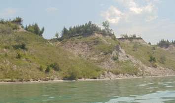
That could result in very high waves and bluff erosion along Lake Huron.
Both the Ausable Bayfield and the Maitland Valley Conservation Authorities have issued water condition statements.
Residents are reminded to stay away from all watercourses and stay well back from breaking waves along the Lake Huron shoreline. The extremely cold water, combined with slippery and potentially unstable stream/lake banks, will have the potential to create hazardous conditions.
The fast flows and cold water can create hazardous conditions around watercourses.
The saturated conditions have also softened the clay till bluffs along Lake Huron's shore, which can lead to slope failure or gully erosion.
Strong winds expected Monday and Tuesday, combined with high water levels, will result in very high waves along the shore, minor flooding, and bluff erosion.