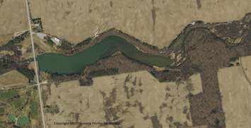
The Ausable Bayfield Conservation Authority introduced the latest in aerial photography to board members this week. The conservation authority uses the images in planning, regulation and stewardship programs.
IT GIS co-ordinator Tracy McPherson says by updating the photography every four or five years, they are able to monitor any changes in the watershed, and that helps them with those programs.
McPherson says one of the feature of the technology is that it allows them to see tile drains in a field below the surface. They can view the images on a 3D system and map out all of the water courses and tile drainage systems.
These new aerial images are being made available to the planning departments within their watershed, and McPherson says they should eventually be made available to the public on the county web sites.