The Municipality of Chatham-Kent anticipates interim work for the realignment of Talbot Trail will be complete by next Summer.
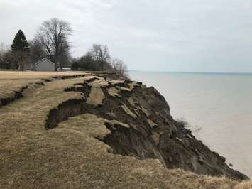
A portion of Talbot Trail from Coatsworth Road to approximately 800 metres east of Coatsworth Road was closed in 2019 due to the risk of slope and road failure from the regressing and unstable bluff slope along Lake Erie.
Talbot Trail will be relocated to the northwest of its existing alignment between Coatsworth Road and 3089 Talbot Trail in the short-term.
The long-term solution is to build a new road from Ellerbeck Road to Stevenson Road, along the existing 2nd Concession Line. The work requires significant property acquisition, road improvements, and utility relocations, according to the municipality. When complete, the entire road will be away from the lake to protect it from erosion for a minimum of 30 years.
Chatham-Kent Manager of Engineering Mark McFadden previously told council the work is estimated to take 3-4 years to complete including acquiring the necessary land.
Officials said the detailed design is currently underway and will be finalized this Summer, adding the construction contract is set to go out for tender immediately following provincial approval of archaeological work currently underway.
That approval should be received this Fall, the municipality believed, adding the proposed alignment and pavement structure of the new roadway have been finalized.
However, the design of the roadside drainage and relocation of both private and public utilities is ongoing.
"The private utility companies including Hydro One, Enbridge Gas, and the telecommunication companies have all been engaged to coordinate the relocation of their infrastructure to the new municipal right-of-way (ROW) and reconnection of private services during the construction of the roadway," said administration. "The existing watermain will also be relocated to the new municipal ROW and existing service connections will be reconnected."
Work to relocate or protect existing private utilities, such as underground power cables, stormwater management infrastructure, and waterlines is underway and existing driveways within the project area will be adjusted as needed to ensure all properties have access from the new municipal right-of-way, said officials.
They also said four private properties north of the existing Talbot Trail still need to be acquired by the municipality to build the new roadway, adding that the land appraisals have been completed for each of the four impacted lots.
"Discussions are underway with the landowners and it is anticipated that the land acquisition recommendations will be prepared for council review and approval in Summer 2025," staff noted.
The project is estimated to cost $6.7 million, including all design, field investigations, archaeological assessments, land acquisition, and construction.
Chatham-Kent council will be asked at its meeting on Monday night to approve further archaeological assessment because several artifacts were found, including decorated pottery.
Multiple First Nations groups have also been involved in the fieldwork, according to the municipality.