Prolonged periods of rain and strong winds have prompted the local conservation authorities to issue flood warnings for the area.
According to the St. Clair Region Conservation Authority (SRCA), gauges within the watershed have reported upwards of 100 millimetres of rain since Tuesday. An additional 20-40 mm of rain is anticipated by Thursday morning.
Environment Canada issued a Gale Warning for both western Lake Erie and Lake St. Clair Wednesday as wind gusts up to 80 kilometres per hour are anticipated to blow across Lake St. Clair this evening.The winds are predicted to remain strong overnight Wednesday and into Thursday causing waves on the lake to reach around 1 metre this evening. Waves on Lake Erie could reach closer to 2 metres.
On top of a rainfall warning still in effect for the area and high lake levels, there is a risk the waves could damage the shoreline and cause erosion along Lake Erie in Chatham-Kent and Lake St. Clair in Lakeshore. The significant amount of rain the area has already received and predicted could also cause localized flooding, ponding and drainage issues in some areas.
"Water levels are rising quickly and breaching [bank] limits. The upper reaches of the Sydenham River are anticipated to peak early Thursday morning, followed by mid-watershed areas late Thursday morning to mid-afternoon," said Water Resources Specialist Emily De Cloet. "As the water moves through the system, water levels in the lower reaches near Dresden and Wallaceburg are anticipated to peak late Thursday evening."
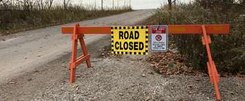
Meanwhile, a flood warning was also issued on Thursday morning by the Lower Thames Valley Conservation Authority (LTVCA) for Erie Shore Drive.
According to the LTVCA, flooding has already started along the roadway and the public is being asked to avoid the area for the time being.
"There is currently flooding along Erie Shore Drive in Chatham-Kent," LTVCA officials said through a media release. "Standing water is building up on properties and water is already passing over the roadway in multiple locations. Forecasts suggest flooding will continue into the evening, or possibly into the overnight period, when winds are predicted to drop off and shift more to the west.
A flood watch remains in effect for other areas of the Lake Erie shoreline in Chatham-Kent.
The conservation authority advises residents to avoid the shoreline if conditions worsen as waves can be strong and the shoreline can become slippery.